Water Woes in Doñana National Park
Downloads
- donanagw_oli_2018_lrg.jpg (2817x2480, JPEG)
- SpainLakes_pho_2011_2022_lrg.jpg (1222x578, JPEG)
Metadata
- Sensor(s):
- Landsat 5 - TM
- Landsat 7 - ETM+
- Landsat 8 - OLI
- Data Date:
- Visualization Date: June 23, 2023
Change is at the heart of Doñana National Park in southwestern Spain. Within its boundaries, thousands of small, shallow ponds fed by groundwater undergo natural cycles of flooding and drought. Known as Mediterranean temporary ponds, the habitat contains plants and animals that are specially adapted to the intermittent availability of water. Doñana’s marshes, wetlands, and dunes provide habitat for hundreds of bird species, along with rare animals such as the Spanish imperial eagle and the endangered Iberian lynx.
Over the past several decades, however, a more insidious kind of change has been altering the landscape at Doñana. The same groundwater that drives the wetland’s flooding cycles is also accessible for uses outside of the national park. The footprint of the aquifer feeding the ponds is about five times that of the protected area. Agriculture and tourism beyond the park’s borders have increasingly taxed that water supply.
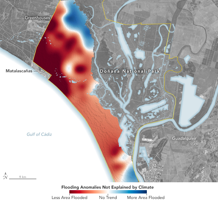
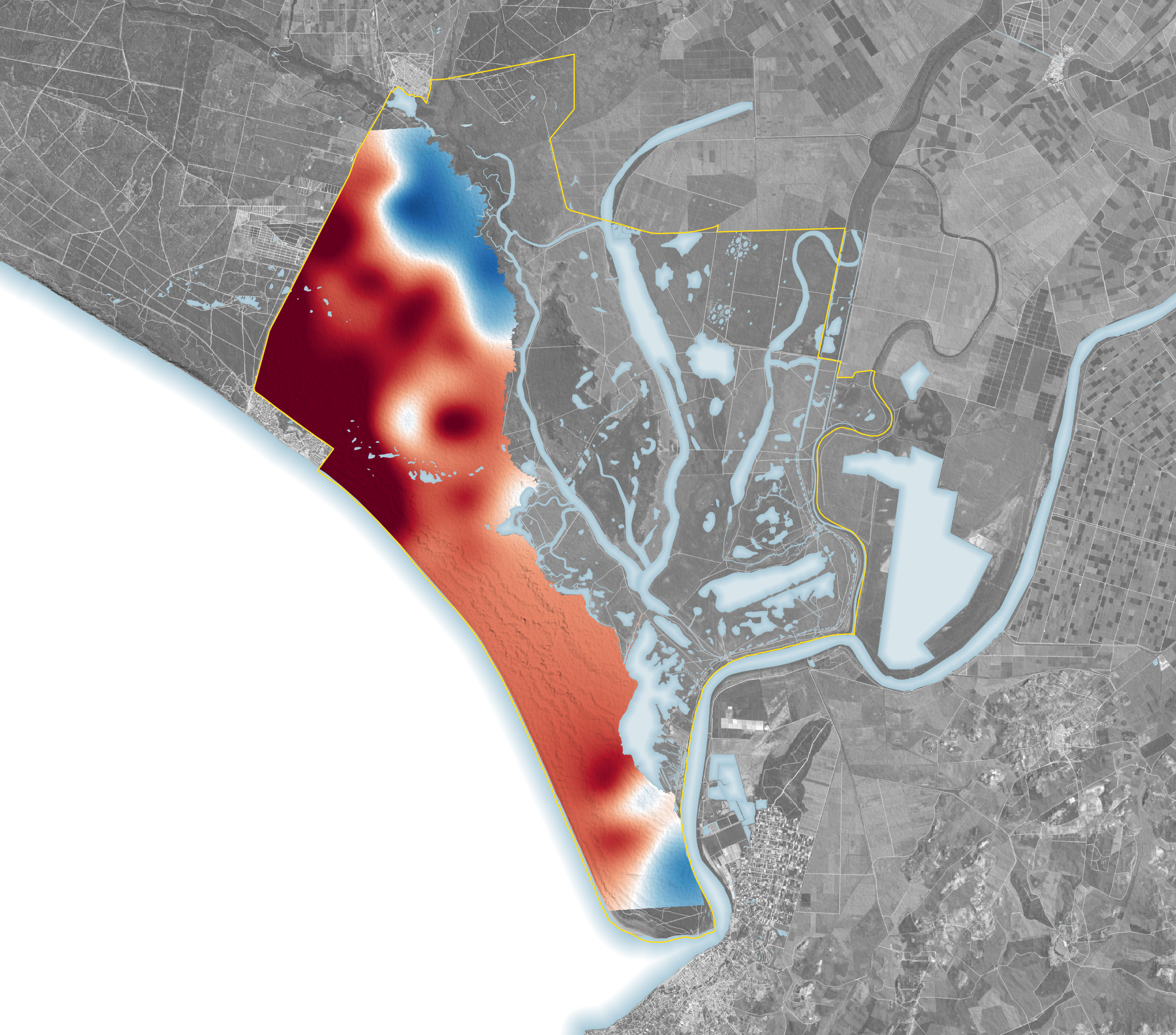
A recent study used over three decades of satellite data to understand how human demands on the aquifer have affected the ponds. The map above highlights where ponds now flood more or less than can be explained by climate. To arrive at their result, scientists at the Doñana Biological Station used Landsat images to quantify the extent and duration of flooding in 316 ponds between 1985 and 2018. Next, they incorporated temperature, rainfall, and land-use data from that time to model how much flooding was due to climatic versus anthropogenic factors.
In large part, they concluded, groundwater usage caused most of the ponds analyzed to flood less often, and in some cases dry out completely. The most noticeable impacts appear directly adjacent to where water is pumped. Along the coast, the resort town of Matalascañas has built up since the 1970s and taps into groundwater. A golf course that operated there for 17 years reduced pond flooding during that time. On the western fringe of the park, greenhouses growing strawberries and other berry crops draw from the aquifer for irrigation.
Not all areas trended toward drying up. Eight ponds in the northern part of the park flooded more than expected relative to climate, the study found. The authors speculate that stream restoration and the removal of a eucalyptus plantation in the early 2000s could explain this result.
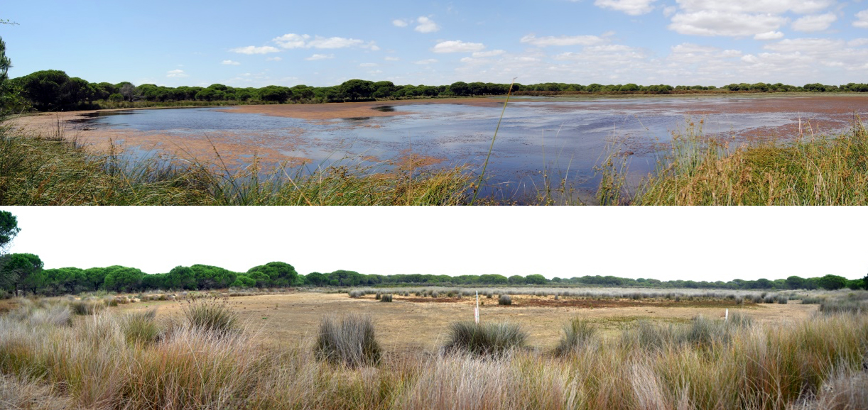
All told, of the several hundred ponds studied, 59 percent have not flooded since at least 2013, and 83 percent are flooding less extensively—and for less time—than would be explained by climate. The photos above show the Zahillo pond, located approximately 2 kilometers from the resort area, in June 2011 (top) and October 2022 (bottom). Before 2011, it was quite common for the pond to stay flooded year-round, said Miguel de Felipe, a wetland ecologist and lead author of the study. Recently, only small areas within the basin have flooded and scrubland vegetation has begun to fill in.
Doñana is designated a UNESCO World Heritage Site and Biosphere Reserve, as well as a Ramsar Wetland of International Importance. However, development outside the protected area—on top of prolonged drought—has taxed the shared aquifer and imperiled the ecosystem and its protected status.
Over the past few decades, farmers near the wetland have shifted from growing drought-tolerant crops such as olives and grains to more water-intensive ones, particularly strawberries. Spain is a top exporter of strawberries, and most of them are grown in the province of Huelva, where Doñana is located.
References & Resources
- AP News (2023, April 12) Andalusia considers more irrigation near Spanish wetlands. Accessed June 23, 2023.
- de Felipe, M., et al. (2023) Thirty-four years of Landsat monitoring reveal long-term effects of groundwater abstractions on a World Heritage Site wetland. Science of the Total Environment, 880(1), 163329.
- Ministry for the Ecological Transition and the Demographic Challenge Doñana National Park. Accessed June 23, 2023.
- Natura 2000 (2008, July 24) Mediterranean Temporary Ponds (pdf). Accessed June 23, 2023.
- Science (2023, April 21) Farming bill threatens Spain’s most important wetland, scientists say. Accessed June 23, 2023.
NASA Earth Observatory image by Lauren Dauphin, using data from de Felipe, Miguel, et al. (2023). Photos by Carmen Díaz Paniagua. Story by Lindsey Doermann.
This image record originally appeared on the Earth Observatory. Click here to view the full, original record.